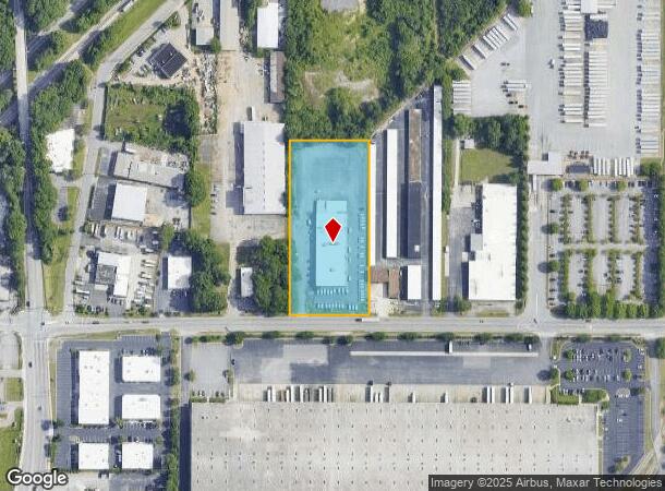
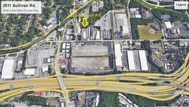
Property Record
2511 Sullivan Rd, Atlanta, GA 30337

NEARBY LISTINGS FOR SALE OR LEASE
Property Detail
2511 Sullivan Rd
Warehouse
Fulton
X
Georgia
13121C0363F
3 AC
2024
Airport/North Clayton
2025
Atlanta
010604
Atlanta-Sandy Springs-Roswell, GA
21,355 SF
13-0036-LL-087-9
DEMOGRAPHICS near 2511 Sullivan Rd
1 Mile
3 Mile
5 Mile
2024 Total Population
6,597
61,624
164,860
2029 Population
7,082
63,731
169,120
Pop Growth 2024-2029
+ 7.35%
+ 3.42%
+ 2.58%
Average Age
36
36
37
2024 Total Households
2,579
24,394
66,123
HH Growth 2024-2029
+ 7.33%
+ 3.37%
+ 2.57%
Median Household Inc
$36,207
$46,879
$51,881
Avg Household Size
2.50
2.50
2.40
2024 Avg HH Vehicles
1.00
1.00
1.00
Median Home Value
$172,798
$172,298
$186,996
Median Year Built
1975
1979
1982
Nearby Places
Map Layers
Map Styles
 Street
 Aerial
- Restaurants
- Banks
- Shops
- Fitness
- Groceries
PUBLIC TRANSPORTATION
AIRPORT
Hartsfield - Jackson Atlanta International
DRIVE
WALK
Distance
Hartsfield - Jackson Atlanta International
12 min
6.5 mi
Freight Ports
Georgia Ports - Savannah
DRIVE
WALK
Distance
Georgia Ports - Savannah
274 min
243.8 mi
SALE & LEASE HISTORY
LISTING DATE
SALE/LEASE

Sep 13, 2023
For Lease
Feb 09, 2023
For Sale
Nearby Properties
Address
Land Use
TOTAL SIZE
Lot Size
Zoning
Address
Land Use
TOTAL SIZE
Lot Size
Zoning
880,465 SF
130.34 AC
C
Address
Land Use
TOTAL SIZE
Lot Size
Zoning
63,992 SF
174.80 AC
HI
Address
Land Use
TOTAL SIZE
Lot Size
Zoning
28,000 SF
246.83 AC
I
Address
Land Use
TOTAL SIZE
Lot Size
Zoning
104.17 AC
C
Address
Land Use
TOTAL SIZE
Lot Size
Zoning
2,666 SF
46.88 AC
BP
Address
Land Use
TOTAL SIZE
Lot Size
Zoning
229.84 AC
HI
Address
Land Use
TOTAL SIZE
Lot Size
Zoning
198.66 AC
I
Address
Land Use
TOTAL SIZE
Lot Size
Zoning
2,666 SF
0.43 AC
Address
Land Use
TOTAL SIZE
Lot Size
Zoning
2,666 SF
0.43 AC
Address
Land Use
TOTAL SIZE
Lot Size
Zoning
2,666 SF
0.43 AC
Address
Land Use
TOTAL SIZE
Lot Size
Zoning
2,666 SF
0.43 AC
Address
Land Use
TOTAL SIZE
Lot Size
Zoning
2,666 SF
0.43 AC
Address
Land Use
TOTAL SIZE
Lot Size
Zoning
2,666 SF
0.43 AC
Address
Land Use
TOTAL SIZE
Lot Size
Zoning
2,666 SF
0.43 AC
Address
Land Use
TOTAL SIZE
Lot Size
Zoning
2,666 SF
0.43 AC
Address
Land Use
TOTAL SIZE
Lot Size
Zoning
2,666 SF
0.43 AC
Address
Land Use
TOTAL SIZE
Lot Size
Zoning
2,666 SF
0.43 AC
Address
Land Use
TOTAL SIZE
Lot Size
Zoning
293,211 SF
23.51 AC
C
Address
Land Use
TOTAL SIZE
Lot Size
Zoning
270,503 SF
4.56 AC
C
Address
Land Use
TOTAL SIZE
Lot Size
Zoning
2,059,074 SF
13.91 AC
R3
Address
Land Use
TOTAL SIZE
Lot Size
Zoning
2,329,350 SF
32.55 AC
A
Address
Land Use
TOTAL SIZE
Lot Size
Zoning
196,294 SF
0.49 AC
R1
Address
Land Use
TOTAL SIZE
Lot Size
Zoning
115.30 AC
I
Address
Land Use
TOTAL SIZE
Lot Size
Zoning
6,402,340 SF
22.62 AC
MF
Address
Land Use
TOTAL SIZE
Lot Size
Zoning
699 SF
44.34 AC
RM
Address
Land Use
TOTAL SIZE
Lot Size
Zoning
1,231,833 SF
15.51 AC
C2
Address
Land Use
TOTAL SIZE
Lot Size
Zoning
4,381,104 SF
26.70 AC
AG1
Address
Land Use
TOTAL SIZE
Lot Size
Zoning
235,301 SF
27.20 AC
C2MC
Address
Land Use
TOTAL SIZE
Lot Size
Zoning
32,000 SF
8.86 AC
C
Address
Land Use
TOTAL SIZE
Lot Size
Zoning
165,096 SF
137.54 AC
M1
The World's #1 Commercial Real Estate Marketplace
Connect with us
© 2025 CoStar Group
The information above has been obtained from sources believed reliable. While we do not doubt its accuracy we have not verified it and make no guarantee, warranty or representation about it. It is your responsibility to independently confirm its accuracy and completeness. Any projections, opinions, assumptions, or estimates used are for example only and do not represent the current or future performance of the property. The value of this transaction to you depends on tax and other factors which should be evaluated by your tax, financial, and legal advisors. You and your advisors should conduct a careful, independent investigation of the property to determine to your satisfaction the suitability of the property for your needs.